Telinject ®
South Africa
Distributor and Sales Representative of AirRobot® GmbH & Co. KG for Africa and the Middle East
Phone: (+27) 084 896 3502
Fax: (+27) 086 620 7069
Skype: sealatseal
Linkedin: klaus-o-weber
Webpage: www.ciprointernational.com

An unmanned aerial vehicle (UAV), commonly known as a drone is an aircraft without a human pilot on board. Its flight is either controlled autonomously by computers in the vehicle, or under the remote control of a pilot on the ground or in another vehicle. There are a wide variety of drone sizes, configurations, and characteristics. Historically, UAVs were simple remotely piloted aircraft, but autonomous control is increasingly being employed. They are predominantly deployed for military and law enforcement applications, but also used in a small but growing number of civil applications, such as firefighting and nonmilitary security work, such as surveillance of pipelines, traffic and other applications. UAVs are often preferred for missions that are too "dull, dirty, or dangerous" for manned aircraft.
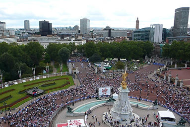
Commercial aerial surveillance
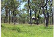
Aerial surveillance of large areas is made possible with low cost UAV systems. Surveillance applications include: nature conservation, anti-poaching, wildlife census, sea and coastline surveillance, research and protection, fishery protection and research, agriculture research and crop protection, livestock monitoring, wildfire mapping, pipeline security, home security, road patrol and anti-piracy. The trend for use of UAV technology in commercial aerial surveillance is expanding rapidly with increased development of automated object detection approaches.
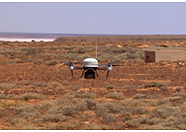
Unmanned Aerial Vehicle (UAV)
AGRICULTURE, FORESTRY, WILDLIFE PROTECTION,
NATURE CONSERVATION, FISHERY and SEA
RESEARCH, INSPECTIONS and SECURITY
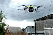
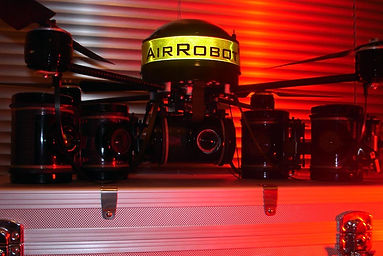
AirRobot ®


The universal platform for aerial surveillance, survey, security and documentation
Aerial Security with micro drones
-
Anti-looting control
-
Coastal Surveillance
-
Illegal Activity Control
-
Illegal Excavation Control
-
International Summit Surveillance
-
Road Traffic Surveillance
-
Emergency comms network (incl. relay)
-
Disaster Site Monitoring & Mapping (Earthquake)
-
Disaster Site Monitoring & Mapping (Mudslide)
-
Disaster Site Monitoring & Mapping (Train Crashes)
-
Nuclear Accident - Contamination Measurement
-
Search for Missing Persons
-
Forestry Management & Research Aerial Terrain Mapping (Industrial Site)
-
Anti-Piracy Operations
-
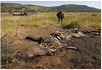
Anti-poaching control
-
Crime Scene Recording
-
Waste Burning Control
-
Illegal Logging Control
-
Police Applications
-
Urban Law Enforcement
-
Fire Scene Inspection (Pre / During / Post)
-
Disaster Site Monitoring & Mapping (Floods)
-
Disaster Site Monitoring & Mapping (Plane Crash)
-
Disaster Site Monitoring & Mapping (Tsunami & Tidal Surge)
-
Nuclear Accident - Contamination Tracking & Monitoring
-
Volcanic Ash Cloud (Analysis)
-
Ocean & Sea Research Support
-
Critical Infrastructure Inspection
-
Border Surveillance
-
Anti-terrorist operations
-
Crime Situational Awareness
-
Historic Site Control
-
Illegal Mining
-
Riot Control
-
Wildlife Crime Control
-
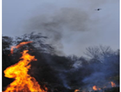
Forest Fire Fighting (Detection / Monitoring / Support)
-
Disaster Site Monitoring & Mapping (Icing Rain Storms)
-
Disaster Site Monitoring & Mapping (Ship Collision)
-
Disaster Site Monitoring & Mapping (Volcano Eruption)
-
Post-Disaster Relief Operations
-
Volcanic Ash Cloud (Tracking & Monitoring)
-
Aerial Terrain Mapping (Urban Environment)
-
Forest Fire Operations Support
-
Coastal Surveillance
-
Border Surveillance
-
Hostile Protest Control
-
Heritage Looting Control
-
Illegal Ship Bilge Venting
-
International Summit Surveillance
-
Dike Monitoring
-
Disaster Site Monitoring & Mapping
-
Disaster Site Monitoring & Mapping (Landslide)
-
Disaster Site Monitoring & Mapping (Storm & Hurricane)
-
Nuclear Accident Monitoring
-
Road & Highway Traffic Monitoring
-
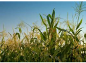
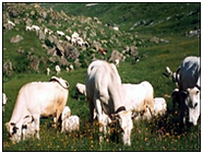
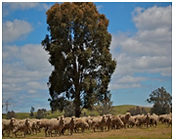
Agriculture (Crop Monitoring & Management)
-
Aerial Terrain Mapping (Non-Urban Environment)
-
Perimeter Surveillance
-
Radiation Measurement & Monitoring


Aerial Inspection with micro drones
-
Solar Panels
-
Agriculture (Crop Monitoring & Management)
-
Wildlife Census
-
Critical Infrastructure Inspection
-
Thermal Isolation Analysis (Buildings)
-
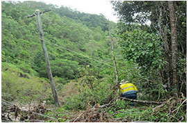
Power Line / Cable
-
Cooling Tower
-
Algae Proliferation Detection
-
Aerial Terrain Mapping (Urban Environment)
-
Gas Burn-Off Stack Tip Inspection
-
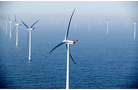
Wind Turbine Blade Inspection
-
Bridge Inspections
-
Forestry Management & Research
-
Aerial Terrain Mapping (Non-Urban Environment)
-
Historical Monument Inspection
-
Railway Track Bed
-
Flair-Tip-Inspection
-
Salt Water Infiltration Detection
-
Aerial Terrain Mapping (Industrial Site)
-
Radiation Measurement & Monitoring
Conservation
The WWF announced it will begin using UAVs to aid conservation efforts, following a successful trial of two aircraft in Chitwan National Park, with ambitions to expand to other countries. The global wildlife organization plans to train ten personnel to use the drones, with operational use beginning in the fall.
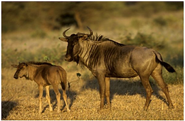
Poaching
Poaching has the potential to cause endangered species to go extinct, as it severely lowers the number of animals found in the wild if not stopped. For example, the number of tigers in the wild has severely declined to less than 3,500. This is caused mostly by the high price the body parts of the tiger fetches on the black market, and the belief that parts such as their bones can be used as medicine. Fragile ecosystems can be severely impacted by the illegal killing of animals. These effects could be irreversible, and devastating.
In the case of the tiger, if the species goes extinct, it could collapse an entire ecosystem. Since the tiger is a predator, the lack of tigers could cause the numbers of the animals they prey on - primarily herbavores - to increase exponentially. The increase of typically-hunted herbivores and the lack of predators in the wild could cause the amount of natural flora to diminish, and exhaust the food supply of other animals, thus destroying an entire food chain.
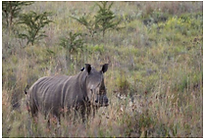
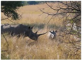
Rhinoceros are killed by humans for their horns, which are bought and sold on the black market, and which are used by some cultures for ornamental or traditional medicinal purposes. The horns are made of keratin, the same type of protein that makes up hair and fingernails. Both African species and the Sumatran rhinoceros have two horns, while the Indian and Javan rhinoceros have a single horn. The three of the species as critically endangered.

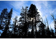
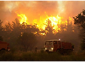
Forest fire detection
Another application of civil UAVs is prevention and early detection of forest fires. The possibility of constant flight, both day and night, makes the methods used until now (helicopters, watchtowers ...) becoming obsolete. Its payload is provided by numerous cameras (HD, thermal, hyper spectral ...) and multiple sensors that provide real-time emergency services not only information about the location of the outbreak of fire, too many data (wind speed temperature, humidity ...) that are helpful for fire crews to conduct fire suppression.
Domestic aerial surveillance
Although UAVs are today most commonly associated with military actions, UAVs are increasingly being used by civilian government agencies, businesses, and private individuals. In the United States, Canada and Europe, for example, government agencies use drones to patrol the nation's borders, scout property, hunt down fugitives, protected there fishery and wildlife and many other applications. The AirRobot® is one of the first UAV authorized for domestic usage for law enforcement, emergency services and civilian applications in Europe.

AirRobot® the universal platform for aerial surveillance, survey and documentation, the special mini and micro UAV systems is used in the civil, nature conservation, disaster management, law enforcement and military sector. An unmanned aerial vehicle (UAV), commonly known as a drone is an aircraft without a human pilot on board. Its flight is either controlled autonomously by computers in the vehicle, or under the remote control of a navigator, or pilot on the ground or in another vehicle. AirRobot has a variety of drone shapes, sizes, configurations, and characteristics. Historically, UAVs were simple remotely piloted aircraft, but autonomous control is increasingly being employed. They are predominantly deployed for military and law enforcement applications, but also used in a small but growing number of civil applications, such as firefighting, wildlife protection and monitoring, nonmilitary security work, such as surveillance of pipelines. UAVs are often preferred for missions that are too 'dull, dirty, or dangerous' for manned aircraft.

Classification
Although UAVs are fixed-wing aircraft or rotorcraft, UAVs typically fall into one of six functional categories (although multi-role airframe platforms are becoming more prevalent):
-
Target and decoy – providing ground and aerial gunnery a target that simulates an enemy aircraft or missile
-
Reconnaissance – providing battlefield intelligence
-
Combat – providing attack capability for high-risk missions
-
Logistics – UAVs specifically designed for cargo and logistics operation
-
Research and development – used to further develop UAV technologies to be integrated into field deployed UAV aircraft
-
Border protection and monitoring
-
Counterterrorism application
-
Traffic monitoring and control
-
Different Law Enforcement application